


Runnelstown Voting District, Perry County, Mississippi
About
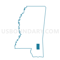
Outline

Summary
| Unique Area Identifier | 606458 |
| Name | Runnelstown Voting District |
| County | Perry County |
| State | Mississippi |
| Area (square miles) | 58.15 |
| Land Area (square miles) | 58.06 |
| Water Area (square miles) | 0.09 |
| % of Land Area | 99.85 |
| % of Water Area | 0.15 |
| Latitude of the Internal Point | 31.38580560 |
| Longtitude of the Internal Point | -89.08115450 |
Maps


Graphs
Select a template below for downloading or customizing gragh for Runnelstown Voting District, Perry County, Mississippi


Neighbors
Neighoring Voting District (by Name) Neighboring Voting District on the Map
- Barrontown-Macedonia Voting District, Forrest County, MS
- Holly Street Voting District, Perry County, MS
- Indian Springs Voting District, Perry County, MS
- Ovett Voting District, Jones County, MS
- Prospect Voting District, Perry County, MS
- Richton Multi-Purpose Voting District, Perry County, MS
- Sunrise Voting District, Forrest County, MS
- Union Voting District, Jones County, MS
Top 10 Neighboring County Subdivision (by Population) Neighboring County Subdivision on the Map
- District 3, Forrest County, MS (17,789)
- District 4, Jones County, MS (15,997)
- District 3, Jones County, MS (13,443)
- District 2, Perry County, MS (2,836)
- District 4, Perry County, MS (2,457)
- District 3, Perry County, MS (2,384)
- District 1, Perry County, MS (2,130)
Top 10 Neighboring Unified School District (by Population) Neighboring Unified School District on the Map
- Jones County School District, MS (49,698)
- Petal School District, MS (19,483)
- Perry County Schools, MS (8,511)
- Richton School District, MS (3,739)
Top 10 Neighboring State Legislative District Lower Chamber (by Population) Neighboring State Legislative District Lower Chamber on the Map
- State House District 104, MS (28,940)
- State House District 88, MS (25,071)
- State House District 86, MS (21,915)
Top 10 Neighboring State Legislative District Upper Chamber (by Population) Neighboring State Legislative District Upper Chamber on the Map
- State Senate District 44, MS (71,264)
- State Senate District 45, MS (57,871)
- State Senate District 42, MS (57,263)
Top 10 Neighboring 111th Congressional District (by Population) Neighboring 111th Congressional District on the Map
Top 10 Neighboring Census Tract (by Population) Neighboring Census Tract on the Map
- Census Tract 9509, Jones County, MS (7,677)
- Census Tract 101.02, Forrest County, MS (6,153)
- Census Tract 101.01, Forrest County, MS (5,622)
- Census Tract 9501.01, Perry County, MS (4,701)
- Census Tract 9501.02, Perry County, MS (3,877)